
The world is vast, filled with winding roads, hidden trails, and uncharted waters. Since the early days of global positioning, Garmin has stood at the forefront, guiding adventurers, athletes, and daily commuters alike. What is Garmin GPS? It’s more than just a navigational tool; it’s a dynamic ecosystem empowering us to explore, train, and connect with confidence.
The Foundation: How Global Positioning Works (Briefly)
At its core, all GPS navigation relies on the same fundamental technology: the Global Positioning System. This network of satellites, managed by the U.S. government, constantly broadcasts precise time and location data. A GPS receiver, like those in Garmin devices, picks up signals from multiple satellites. By calculating the time it took for each signal to arrive, the receiver can triangulate its exact latitude, longitude, altitude, and even velocity. Garmin has spent decades perfecting the accuracy and speed of this data interpretation, making it a market leader.
More than Meets the Eye: The Garmin Ecosystem
The magic of Garmin doesn’t just lie in the satellite connection. It’s the sophisticated software, detailed maps, and specialized features tailored to specific activities that define the user experience. Garmin devices are diverse, from wrist-worn fitness trackers to massive marine chartplotters, and each integrates seamlessly into a powerful, data-driven ecosystem.
The Pillars of Garmin GPS:
- Exploration (Automotive & Outdoor): The traditional heart of Garmin GPS. For drivers, this means intuitive, turn-by-turn navigation that can adapt to traffic and suggest routes based on vehicle size (critical for RVs and commercial trucks). In the outdoors, it means rugged, handheld units preloaded with topographic maps, offering features like trackback (tracing your path back), specialized routing (for hiking or cycling), and even satellite communication for emergency assistance.
- Fitness & Wellness (Wearables): This is perhaps the most rapidly evolving segment of Garmin’s offerings. Garmin wearables (watches) are powerhouse data-collectors. They track heart rate, sleep, steps, and stress levels. But their true strength lies in sport-specific GPS accuracy. Whether you are running a marathon, cycling a mountain pass, or swimming open water, the watch precisely logs your distance, pace, elevation gain, and maps your route with incredible fidelity. This data isn’t just displayed; it’s analyzed to provide metrics like Training Load, Recovery Time, and VO2 Max, guiding athletes towards peak performance.
- Marine (Chartplotters & Sonar): On the water, Garmin dominates with advanced chartplotters. These aren’t just maps; they are digital charts that integrate depth sounders (sonar) to display underwater structures, fish arches, and precise topography of the seabed. When connected to other onboard systems (like radar or autopilot), they form a central command hub for navigation, safety, and efficient fishing.
The Power of Connection: The Garmin Connect App
The key that unlocks the true potential of most Garmin devices is the Garmin Connect mobile app (and web portal). When your wearable or handheld syncs with the app, the data transforms. Users can analyze workouts in granular detail, compare performance over time, join challenges with friends, share achievements on social media, and even plan new routes with the extensive ‘Courses’ feature. Garmin Connect isn’t just a database; it’s a motivational tool and a community platform.
Innovation that Drives Technology:
Garmin continues to innovate, pushing the boundaries of what a GPS device can do. Key technologies that define the modern Garmin experience include:
- Multi-GNSS Support: Many devices now access multiple satellite networks (not just GPS, but also GLONASS and Galileo), improving accuracy, especially in challenging environments like deep canyons or urban jungles.
- Solar Charging: Integrating Power Glass™ solar charging technology into high-end watches (like the fēnix and Instinct series) significantly extends battery life, allowing adventurers to stay off-grid longer.
- PacePro™: A sophisticated feature for runners that uses GPS data and course topography to provide grade-adjusted pace guidance, helping them manage effort over hilly terrain.
- Garmin Pay™: Contactless payment capability integrated directly into many wearables, providing convenience during workouts or runs.
- Safety & Tracking Features: If an incident is detected (like a fall during a bike ride), some devices can send an automated text message and live GPS location to emergency contacts.
Conclusion: The Future of Navigation is Personal
Garmin GPS is no longer just about knowing where you are on a map. It’s about knowing how you are performing, what is beneath your boat, and who you can connect with along the journey. Whether guiding a commercial flight, aiding a marine rescue, tracking a marathon runner, or helping a family find their campsite, Garmin technology empowers people to pursue their passions with confidence and data-driven insight. As we look to the future, the technology will become more personalized, integrated, and predictive, ensuring that wherever you are, Garmin is there to guide you.
Image Generation Prompt:
A vibrant, dynamic image illustrating the diverse applications of the Garmin GPS ecosystem. The composition features a central Garmin branding logo (G with the stylized ‘N’) radiating outwards. Several overlapping scenes show different user experiences:
- An athlete running on a mountain trail, looking at their rugged Garmin GPS watch (like a Fenix), displaying a map with a red route and elevation graph.
- The cockpit of a powerboat, where a large, multi-screen Garmin chartplotter (like a GPSMAP) displays a detailed nautical chart with depth contours and sonar readings (showing fish arches).
- The interior of a car, where a portable Garmin GPS unit (like a DriveSmart) is mounted on the dashboard, showing a turn-by-turn map and traffic updates.
- A smartphone screen showing the Garmin Connect app, displaying a calendar of workouts, a sleep score graph, and a map of a recently completed run.
The overall mood is active and adventurous, with a focus on seamless connectivity between devices and the central satellite system (indicated by subtle, stylized lines connecting all elements). The color palette is modern, with bright blues, greens, and vibrant accents.
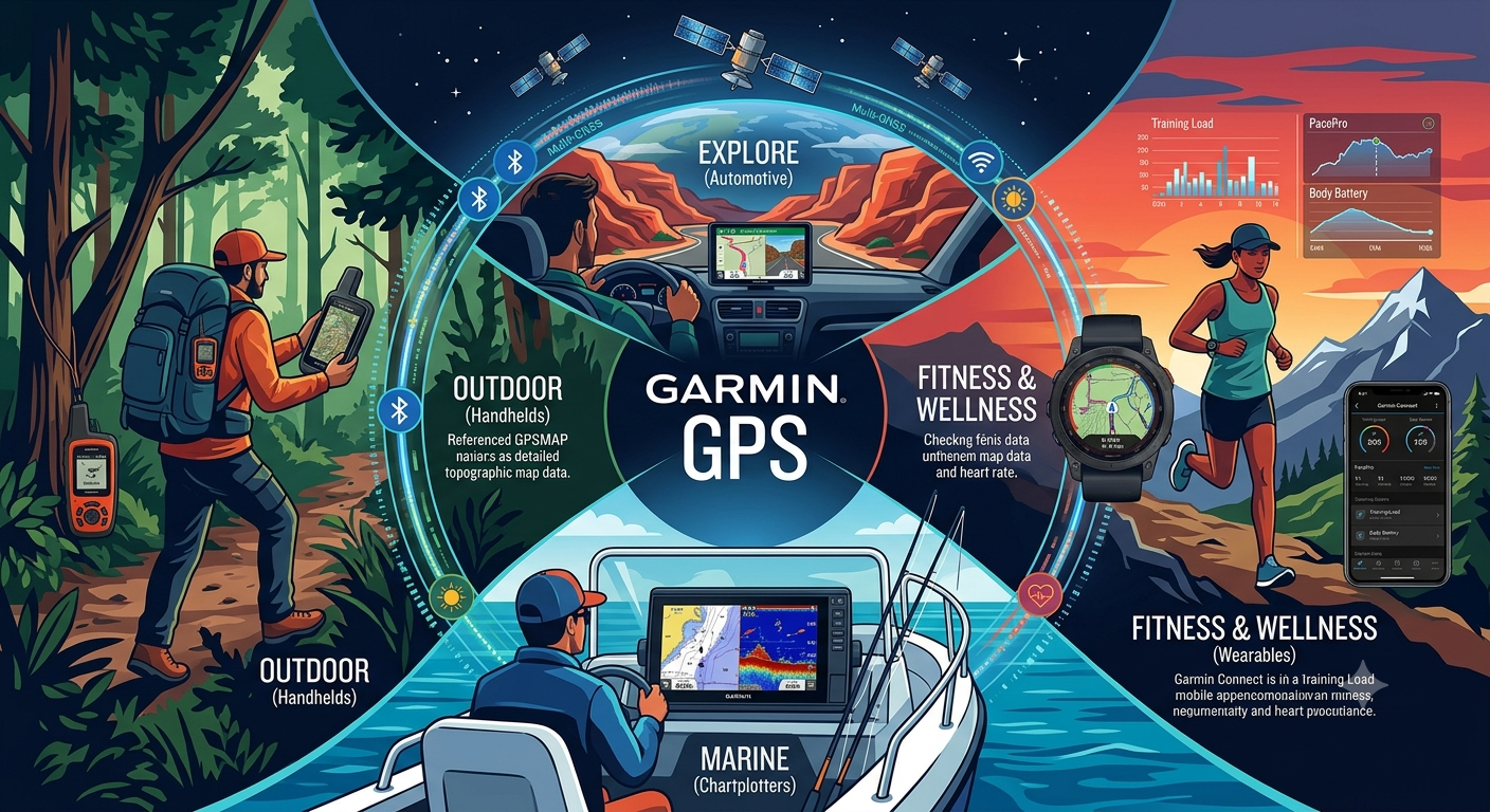
Garmin GPS represents a sophisticated ecosystem of location-based technologies, serving a wide array of specialized needs from daily commuting to extreme outdoor exploration. While the visual guide above beautifully segments these use cases, let’s explore how these different verticals work together under the Garmin umbrella.
The cornerstone of all Garmin devices is the intersection of high-sensitivity hardware with tailored, data-rich software. Unlike a standard smartphone GPS, which often operates on multi-purpose chipsets, Garmin designs its receivers with a focus on acquisition time, signal retention in challenging environments (like deep canyons or heavy tree cover), and energy efficiency. The generated infographic above clearly delineates how this core technology is customized for different environments.
The Ecosystem in Depth: Four Pillars
The visual layout effectively divides the Garmin world into four crucial quadrants, matching the text pillars perfectly.
1. Outdoor (Handhelds): Navigation and Communication Beyond the Grid
The section on the left highlights the “OUTDOOR (Handhelds)” segment. This represents Garmin’s roots and its continued dominance in back-country navigation. Devices like the GPSMAP® series (as referenced in the text) or the touch-screen Montana® series are the lifeline for hikers, geocachers, and hunters.
Their primary strength lies in Topographic Map Integration. As shown in the illustration, the hiker is referencing a detailed contour map. These devices come preloaded with, or support the addition of, maps that show elevation, public land boundaries, and trail networks. Crucially, as mentioned in the text, many of these devices integrate with inReach® satellite communication. This allows for two-way text messaging, live tracking (MapShare), and interactive SOS alerts via the Iridium® satellite network—functions essential when cell service is non-existent.
2. Automotive (Explore): Turning GPS Data into Efficient Travel
The top center segment features “EXPLORE (Automotive).” While almost every smartphone now has a map app, Garmin’s dedicated automotive navigators (like the Garmin Drive™ or dēzl™ for trucking) offer specific advantages. These include:
- Offline Mapping: Maps are stored onboard, meaning routing works instantly without eating data or failing when reception is spotty.
- Specialized Routing: As noted in the main article, models for RVs and semi-trucks calculate routes based on vehicle size, weight, and hazardous materials, preventing drivers from encountering low bridges or restricted roads.
- Driver Alerts: Garmin devices provide specific alerts for sharp curves, school zones, and red-light cameras, often featuring integrated dash cams for added security.
3. Fitness & Wellness (Wearables): The Power of Biometric GPS
The segment on the right, “FITNESS & WELLNESS,” illustrates how Garmin revolutionized the wearables market by merging highly accurate GPS tracking with sophisticated biometric data. The user is running with a fēnix®-style smartwatch while a mountain environment highlights the PacePro™ features.
Garmin’s fitness devices (including the Forerunner® and Instinct® series) excel at converting movement into actionable performance metrics. The infographic explicitly labels metrics like Training Load, Recovery Time, and Body Battery™. This isn’t just distance and time; Garmin analyzes heart rate variability, sleep quality, and elevation gain to help athletes understand when to train harder and when to rest. The accompanying Garmin Connect™ smartphone app (shown on the mobile screen) acts as the central data hub for analysis and community sharing.
4. Marine (Chartplotters): A Complete Tactical View of the Water
The bottom segment focuses on “MARINE (Chartplotters).” In a marine environment, navigation is critical for safety and success (e.g., fishing). Garmin GPSMAP® and ECHOMAP™ chartplotters (like the unit shown on the boat dash) go far beyond mapping:
- Sonar Integration: As depicted, the screen shows not just a chart but a detailed visualization of what is beneath the water, including structures, contours, and fish arches. Technology like Panoptix™ LiveScope™ provides real-time, scanning sonar images in remarkable detail.
- BlueChart® g3 Mapping: These charts integrate Garmin and Navionics® data, providing unmatched coverage, clarity, and detail for coastal waters and inland lakes.
- Autopilot and Radar Control: A Garmin chartplotter acts as the nervous system of the boat, often controlling autopilot systems, displaying radar data for collision avoidance, and interfacing with engine metrics via NMEA 2000®.
Synergy and Connectivity
What brings all of these segments together is connectivity. The illustration emphasizes this with glowing rings connecting the devices and the satellites above. Most Garmin devices sync seamlessly with the Garmin Connect app, allowing an automotive GPS to send an address to a smartwatch, or a marine sonar unit to share depth contours with other anglers.
Ultimately, Garmin GPS is not just about showing you where you are on a coordinate plane; it is a specialized tool optimized to enhance your capability and safety in the specific environment you are navigating—whether it is an open highway, a deep forest, a coastal waterway, or your own body’s physiological limits.
Also Read: Understanding the Migration: Verizon, AOL, and the End of the Verizon.net Era
Source: Garmin Official Site